Cyclone Narelle Intensifies, Threatening Western Australia After Devastating Northern Territory
Tropical Cyclone Narelle is on a destructive path across Australia, having already wreaked havoc in Queensland and the Northern Territory, with forecasts now indicating it could strike a third state. The system, which made landfall in the Northern Territory over the weekend as a category 3 cyclone, has left behind significant damage and widespread flooding, and meteorologists warn it may re-intensify into a severe tropical cyclone, putting Western Australia, including Perth, at risk.
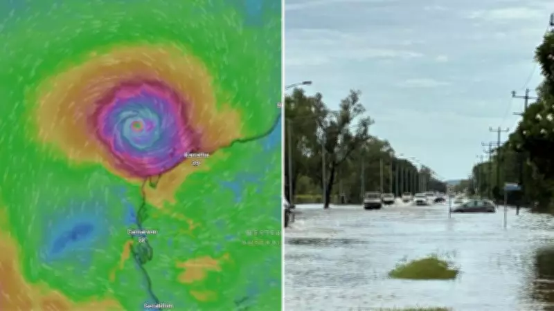
Heavy Rainfall and Flooding Grip the Top End
Ex-Tropical Cyclone Narelle moved across the Top End during Sunday and early Monday, unleashing torrential downpours and strong winds. Meteorologist Ilana Cherny reported rainfall totals between 100mm and 200mm in many areas, with Adelaide River recording 197mm, Central Plateau 170mm, and Howley Creek 166mm. Wind gusts reached up to 80km/h, exacerbating the hazardous conditions.
A severe weather warning remains in place for the western Top End, including Darwin, due to heavy rainfall and damaging wind gusts. The flooding impacts are expected to persist throughout the week, even after the rain subsides. Major flooding has already been observed at Adelaide River and Daly River, with similar conditions anticipated in Nitmiluk and Katherine.

Katherine Faces Renewed Flood Crisis
The tropical low tracked past Katherine overnight, adding to the woes of a community still recovering from floods that occurred just two weeks prior. Northern Territory Chief Minister Lia Finocchiaro emphasized that saturated ground and full rivers mean any additional rainfall will have a severe impact. Flooding along the Katherine River has reached levels not seen in two decades, prompting major flood warnings for several rivers in the region.
Katherine Mayor Joanne Holden described a sense of calm among the exhausted locals, who are banding together to prepare for the latest weather event. She noted that residents are proactively taking necessary steps to mitigate damage, with the community supporting one another during this challenging time.
Western Australia Braces for Potential Impact
As Narelle moves into the northern Kimberley late Monday into Tuesday, a flood watch has been issued for the region. Forecasters predict the system will re-intensify into a severe tropical cyclone as it parallels the Pilbara Coast on Wednesday and Thursday. There is a possibility it could track southward toward the Western Australia west coast by next weekend, potentially affecting Perth.
A cyclone warning zone has been established for the King George River Mouth on the WA/NT border. While showers later in the week might bring some relief to parts of the Wheatbelt, the uncertainty in model scenarios leaves communities on high alert. Residents are urged to stay informed and prepare for potential severe weather conditions as the situation develops.