Ex-Tropical Cyclone Narelle Approaches WA Coast with Severe Weather Threat
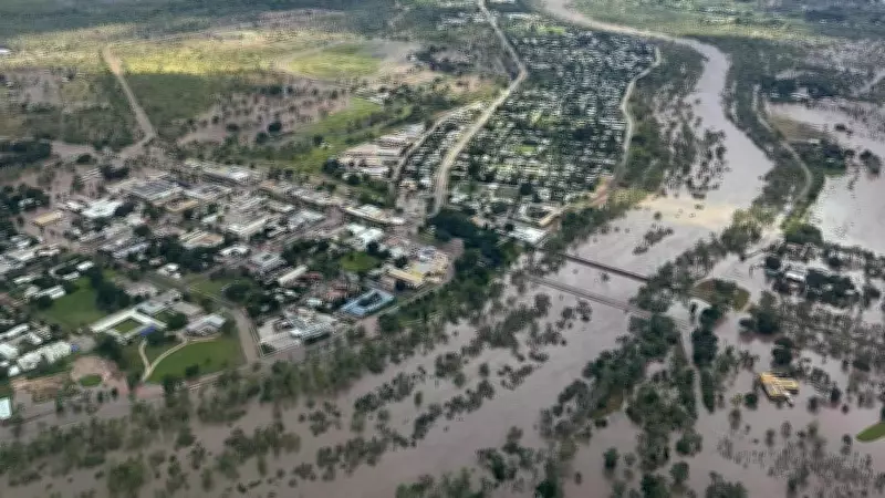
A severe weather warning has been activated for parts of Western Australia's coastline as ex-tropical cyclone Narelle moves westward, posing significant risks of heavy rainfall, flash flooding, and damaging winds. This weather system, which previously caused flooding in Katherine, Northern Territory over the weekend, is now bearing down on the Kimberley region.
Projected Path and Impact Areas
Narelle is expected to cross the Kimberley coast north of Wyndham on Monday evening, continuing on a west-southwest trajectory as a deep tropical low toward the northwest Kimberley coast by Tuesday morning. The Bureau of Meteorology has projected intense rainfall at the storm's center, with totals ranging from 80 to 100 millimetres, potentially peaking at 140mm in localized areas.
Damaging winds of up to 65-75km/h are forecast, including peak gusts reaching 90km/h, particularly for regions east of the Mitchell Plateau. These conditions heighten the risk of infrastructure damage and hazardous travel.

Safety Advisories and Emergency Alerts
The Department of Fire and Emergency Services has issued critical safety advice for residents in affected zones. Key recommendations include:
- Seek safe shelter away from trees, power lines, and waterways if outdoors.
- Secure homes by closing curtains and blinds, staying away from windows, and unplugging electrical appliances during lightning.
- Avoid water activities such as boating, swimming, or surfing.
- Remain alert for road hazards like fallen power lines and debris.
- Steer clear of flooded drains, rivers, and streams.
- Exercise caution around fallen trees, damaged structures, and live power lines.
Residents are advised to assess property damage, document it with photos, and contact insurance companies for repairs. For significant damage, such as severe roof issues or flooding, contact the State Emergency Service at 132 500.
Preparedness Measures for Communities
Emergency WA has triggered advice alerts along the northwest coast, covering areas between Kuri Bay and Beagle Bay, as well as Wallal Downs west of Port Hedland. Authorities urge immediate preparation for dangerous weather conditions. Essential steps include:
- Evacuate the warning area if you are a traveller, visitor, or tourist.
- Review and update emergency plans with household members, using resources like the Emergency WA website or app.
- Ensure emergency kits are stocked with items such as first aid supplies and battery-operated AM/FM radios.
- Familiarize yourself with the cyclone warning system and corresponding action steps.
- Monitor updates via the Emergency WA website and other official channels.
Residents are reminded that property preparation is a personal responsibility, with further guidance available at emergency.wa.gov.au/prepare. Real-time updates can be accessed through the Bureau of Meteorology website, TV and radio broadcasts, or by calling 1300 659 210.
This developing situation underscores the unpredictable nature of tropical systems, as Narelle defies earlier forecasts to target Western Australia. Communities are urged to stay informed and prioritize safety during this severe weather event.