Cyclone Narelle Downgraded but Still Poses Major Threat to Northern Territory
Residents across remote Northern Territory towns are preparing for significant impacts as Tropical Cyclone Narelle barrels across the coast after striking parts of Queensland overnight. The system has been downgraded from a dangerous category four to a category two cyclone as it moves through the Gulf of Carpentaria, but meteorologists warn it remains a serious threat to the eastern Top End region.
Queensland Impact Assessment Underway
Senior Bureau of Meteorology meteorologist Angus Hines explained that assessing the damage in Queensland will take time as the sun rises on affected areas. "While at its strongest upon arrival, the destructive core of the tropical cyclone threaded the needle between Lockhart River and Cowen, meaning that neither of these communities faced the full brunt of Narelle," Hines stated.
"Minor damage was reported in each location with wind gusts in excess of 100km/h, but no doubt stronger winds battered the area in between these two regions. It will take some time, especially as the sun is still coming up, to assess what damage has been done through that area."

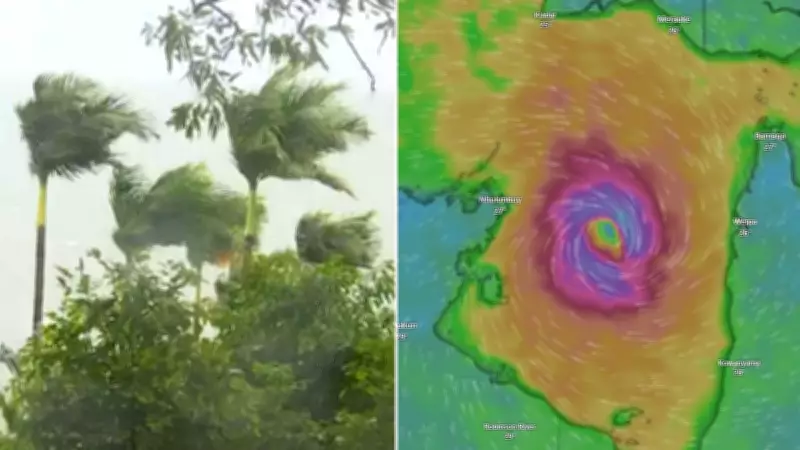
The town of Coen experienced strong winds and rain following the crossing of Tropical Cyclone Narelle, which has weakened after lashing Queensland with destructive winds and heavy precipitation.
Record Rainfall and Flooding Concerns
Rain across the Cape York Peninsula was particularly heavy and persistent on Friday as Narelle surged westwards. Hines revealed that nearly half a metre of rain fell in some locations, creating dangerous flooding conditions.
Key rainfall totals included:
- 422mm at Fall Creek on the Pascoe River
- 408mm at Portland Road on the Wenlock River
- 283mm at Weipa on the west coast of the peninsula
"This widespread heavy rainfall has caused the rivers and creeks across the Cape York Peninsula to rise swiftly and swamp roads as well as other low-lying areas," Hines explained. "This is likely isolating communities up in the far north of Queensland and making it difficult to get out and assess the damage, reach remote locations and top up supplies."
Northern Territory Braces for Impact
Tropical Cyclone Narelle left the west coast of the peninsula on Friday night and moved into the Gulf of Carpentaria. The system currently sits approximately 200km off the west coast of the peninsula as it heads directly for the Northern Territory, with landfall expected on Saturday night.
The Bureau of Meteorology has issued warnings for residents from Nhulunbuy to Port McArthur, including communities such as Borroloola, Numbulwar, Alyangula and Gapuwiyak. Meteorologists predict Narelle will strengthen as it approaches the Territory coastline.
Forecast conditions include:
- Very destructive winds gusting up to 195km/h in some areas into Sunday
- Heavy rainfall that could cause flash flooding
- Potential for the system to strengthen back to category three status
Evacuations and Emergency Preparations
The Australian Defence Force has already evacuated almost 150 people from the Northern Territory community of Numbulwar, with hundreds more scheduled for evacuation flights as Tropical Cyclone Narelle approaches. Approximately 500 people overall are expected to temporarily relocate to a Darwin high school gymnasium in the coming days as they wait out the cyclone's impact.
Hines provided specific timing for the system's approach: "(Narelle) is expected to strengthen today back into a category 3 severe tropical cyclone by around about the middle of the day, all while moving westwards approaching the NT. It will approach the eastern top end coastline tonight, likely passing just to the north of Groote Eylandt as a category 3 system around about 10pm local time this evening, then moving onto the east coast of the Top End mainland during the overnight hours, perhaps around 3 or 4am."

Flooding Concerns for Already Saturated Regions
Rainfall presents a particular concern as this weather system approaches and crosses the Northern Territory on Saturday night and Sunday. Hines emphasized that "given the major flooding which has affected parts of the Territory in recent weeks, especially at the base of the Top End, large rainfall totals will affect much of the Northern Territory during Sunday."
Rainfall predictions include:
- Many locations could receive 100mm to 200mm of rain
- Isolated areas may experience even higher totals
- Heaviest falls expected around the centre and south of top end areas
"Unfortunately, this does mean heavy rain for communities that have been dealing with major flooding in recent weeks, including around Katherine and the Katherine River, Beswick and the Waterhouse River and the communities of Daly River and Nauiyu along the Daly River," Hines warned.
Warning Zones and Community Alerts
A comprehensive cyclone warning zone has been established from Nhulunbuy in the north down to Port McArthur in the south. This warning area includes Groote Eylandt as well as numerous other communities throughout the Central Top End region. Residents in these areas are urged to follow emergency services advice and prepare for potentially dangerous conditions through the weekend.