Ex-Cyclone Narelle Poised for Severe Reintensification Off WA Coast
Forecasters are continuing to predict that ex-Tropical Cyclone Narelle will re-intensify into a severe tropical cyclone as it heads towards the southwest coastline of Western Australia, with the potential to impact Perth directly. The Bureau of Meteorology (BOM) has issued warnings, highlighting the system's trajectory and strength.
Current Status and Movement
As of Tuesday morning, Narelle is moving off the west Kimberley coast, with a high chance of redeveloping into a tropical cyclone over the Indian Ocean by Tuesday night. This marks the third state or territory the system will impact, having previously barrelled through Far North Queensland and the Top End in the Northern Territory.
A cyclone warning zone is currently in effect from Beagle Bay to Kuri Bay, with a watch zone extending from Cape Preston to Wallal Downs, including key locations such as Karratha and Port Hedland. Additionally, a severe weather warning is in place for damaging winds and possible heavy rainfall in the area.

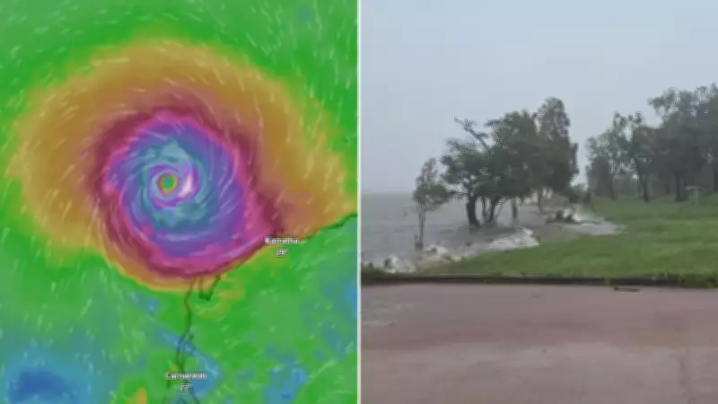
Community Preparedness and Initial Impacts
In Kalumburu, the Aboriginal Corporation chief executive Kim Holm reported that the community's 300 residents experienced heavy rain and wind as the system passed on Monday night, but described it as typical for the wet season. "To us it's pretty normal ... nothing different to what we generally get," she said, noting that emergency services have kept the town well-informed and prepared.
Rainfall totals have been significant, with 146mm recorded in Kalumburu and 166mm in Truscott over the 23 hours leading up to 9am on Tuesday.
Forecasted Development and Potential Impacts
Senior meteorologist Jonathan How provided detailed projections, stating that Narelle is expected to redevelop into a tropical cyclone north of Broome by Tuesday night, maintaining its name. By Wednesday morning, it could reach category 2 strength, and by Wednesday night, it may intensify to severe category 3. Further escalation to severe category 4 is possible by Thursday.
How emphasized that while Narelle is forecast to remain off the Pilbara coast, there is a risk of gale-force and damaging winds along that coastline, accompanied by very large waves. A category 4 system could produce wind gusts of up to 279km/h.
Long-Term Trajectory and Historical Context
Looking towards the weekend, the track map indicates Narelle will curve southwards towards the western coast of Western Australia, maintaining severe status. By Saturday morning, it is expected to lie between Carnarvon and Geraldton.
Beyond this, multiple scenarios are possible. Some projections suggest the system could move onto the coast, bringing heavy rainfall to the Geraldton area and the northern Wheatbelt. Alternatively, it might remain offshore longer and cross further southwest, potentially impacting Perth and the far southwest of WA.
How noted that such events are rare for Western Australia, with the last occurrence being Tropical Cyclone Seroja, which crossed near Kalbarri as a category 3 system. Residents across northern and western parts of the state, including Perth, are urged to stay updated with the latest tropical cyclone outlook forecasts.