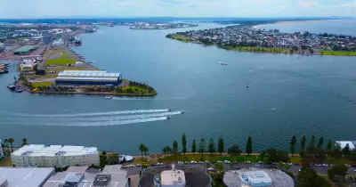
Melburnians have woken to their third consecutive morning of widespread thick fog, as the city and its suburbs remain blanketed in ground-level cloud. The phenomenon is being driven by a highly stable weather pattern, with a high-pressure system sitting over southeastern Australia, combining cool, dewy nights and light winds to produce the dense fog.
Fog Persists Through the Week
The initial fog on Monday was short-lived, but Tuesday's version lingered well into the afternoon in parts of Melbourne's west, Geelong, and the Bellarine Peninsula. By Tuesday evening, fog was already reforming at Avalon Airport just hours after sunset.
The position of the high-pressure system places Melbourne in an ideal location for this fog outbreak, with the western suburbs experiencing the longest-lasting conditions. With the high's centre located just east of the city, light northeasterly morning winds help clear fog over the eastern suburbs first, while consolidating it on the western side of Port Phillip Bay.

The Spillane Eddy Effect
A unique feature over Port Phillip Bay, known as the Spillane Eddy, plays a key role. Researched by Dr Kevin Spillane at CSIRO in the 1970s, this phenomenon occurs when morning fog clears the eastern suburbs but lingers over the bay, persisting into the afternoon. As winds shift from northeasterly to light south to southwesterly with the afternoon seabreeze, the foggy cloud can drift back over land, as seen yesterday afternoon in Albert Park, just southeast of the city.
One more foggy day is expected on Thursday before conditions change. By the end of the week, the high-pressure system will move further east, and an approaching weather system will bring stronger winds by Friday morning, reducing the likelihood of fog.
The fog eventually clears to sunshine, with Wednesday morning showing only wispy high cloud as the eerie fog barely brushes the city. Dry conditions are expected to persist into the weekend, with rain developing slowly by Sunday.