Adelaide has been lashed by another burst of wild winter weather, recording 70 per cent of its median July rainfall in a single day as a vigorous cold front swept across South Australia. The Bureau of Meteorology expects more rain across the Mount Lofty Ranges, Adelaide and the Lower South East on Thursday, before conditions finally ease overnight as the second of two fronts clears to the east.
Record Rainfall and Milestones
Senior forecaster Tom Anderson said 42mm had fallen across metropolitan Adelaide in the past 24 hours, while Longwood and Scott Creek in the Hills each collected more than 60mm. “We’ve also already had 70 per cent of the median rainfall for July in one day,” he said.
The soaking delivered a string of milestones for the city, with the bureau confirming it was Adelaide’s rainiest day since January 26, 2024, the wettest start to July since 1986, and the fifth‑wettest July day on record. Adelaide has now recorded 340mm since the start of the year, well above the usual 313mm typically reached by early July.

Emergency Response and Damage
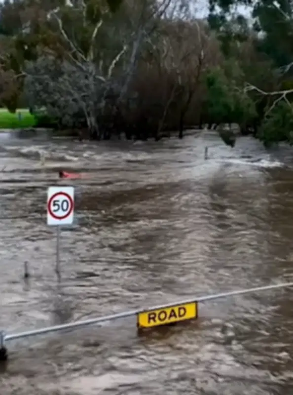
Regional parts of South Australia welcomed the heavy falls, but the wild weather kept emergency crews busy. State Emergency Service (SES) state duty officer Kane Murray said the service had responded to more than 350 calls for help in the past two days, including a large tree that crashed onto a home at Mount Barker. “Most of those have been trees down, and we have seen some minor flooding of businesses and properties as well,” he said.
He warned windy conditions would continue across the South East into Friday. “There is still a bit of a sting in the tail of this system,” he said.
Warnings and Alerts
A severe weather warning for damaging winds remains in place for much of the state’s southern coastline, along with a gale marine wind warning. A flood alert has also been issued for Glenelg as the Patawalonga River swells in Adelaide’s west with the SES warning rising lake levels and a high tide could trigger localised flooding. “There is a risk of localised flooding for the Patawalonga Lake which may threaten you and your family’s safety,” the alert said. The risk period runs until 9pm, with inflows from recent rain already limiting discharge from the lake.
National Impact
The wild conditions are part of a powerful winter system sweeping east across Australia, bringing damaging winds, heavy rain, alpine snow and dangerous surf to several states. New South Wales is expected to bear the brunt, with widespread showers, isolated thunderstorms and strong to damaging winds across inland and coastal districts. Snow will fall across the Snowy Mountains, creating hazardous driving conditions and the risk of fallen trees.
Victoria remains in the firing line with frequent showers, gale‑force coastal winds and accumulating alpine snow keeping conditions dangerous for travellers and marine operators. Tasmania faces another burst of wintry weather as strong westerlies, widespread showers and lowering snow levels move through the Bass Strait.
Southern and south‑east Queensland will see increasing showers later in the week, while Canberra braces for bitter cold as rain eases to showers before temperatures plunge. Frost and icy conditions are likely once skies clear, with snow in nearby alpine areas. The Northern Territory avoids the system entirely, holding onto dry season conditions, while Western Australia enjoys a rare spell of calmer weather under a stabilising high‑pressure ridge.
Weather System and Outlook
The pattern is being driven by a vigorous Southern Ocean cold front and low‑pressure system dragging Antarctic air across southern Australia, generating widespread rain, damaging winds, thunderstorms and alpine snow. The system will weaken as it moves over the Tasman Sea, with high pressure settling conditions in WA.
Forecasters expect much of southern and eastern Australia to trend drier than average through the remainder of winter, despite occasional fronts. The bureau’s long‑range outlook points to warmer‑than‑average temperatures, with a developing El Niño increasing the likelihood of below‑average rainfall in coming months.