Category 3 Cyclone Approaches Far North Queensland with Severe Impact Warning
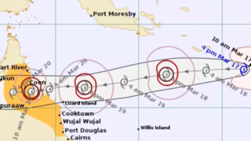
The Bureau of Meteorology has escalated warnings as a Category 3 cyclone sets its sights on Far North Queensland, predicting severe impacts for coastal communities. Residents are being urged to take immediate precautions as the storm intensifies, with potential for destructive winds, heavy rainfall, and dangerous storm surges.
Bureau Issues Urgent Alert for Coastal Regions
Meteorologists have confirmed the cyclone's trajectory, indicating it will make landfall in the coming days. The system is expected to bring sustained winds exceeding 120 kilometers per hour, posing a significant threat to infrastructure and safety. Emergency services are on high alert, coordinating evacuation plans and resource distribution to mitigate risks.
Key concerns include:

- Extensive flooding from torrential rains
- Power outages and communication disruptions
- Damage to homes and businesses from strong winds
- Coastal erosion due to storm surges
Residents Advised to Prepare and Stay Informed
Local authorities are advising residents to secure properties, stock up on essentials, and monitor official updates. Schools and public facilities may close as a precaution, with shelters being prepared for those in vulnerable areas. The cyclone's path could shift, so staying informed through reliable sources is critical.
This event underscores the importance of community readiness during severe weather seasons in tropical regions. Past cyclones have caused substantial damage, highlighting the need for proactive measures. The Bureau continues to track the system closely, providing real-time data to guide response efforts.
As the cyclone approaches, residents are reminded to follow evacuation orders if issued and avoid unnecessary travel. Recovery operations will commence post-impact, with support from state and federal agencies anticipated.