Cyclone Alert: Destructive Winds and Flooding Threaten WA's Pilbara Coast This Weekend
A fierce tropical low developing off the coast of Western Australia is expected to intensify into a significant cyclone over the coming weekend, prompting urgent warnings for residents across the Pilbara region. The system, designated 21U, currently sits near Broome and is forecast to reach category two strength by Saturday night, bringing potentially destructive conditions to coastal communities.
Severe Weather System Intensifying Rapidly
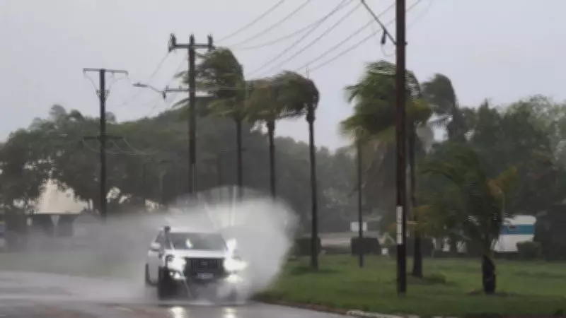
The Bureau of Meteorology has issued detailed warnings about the developing cyclone's expected path and intensity. Meteorologists predict the system will turn south-westerly as it approaches the Pilbara coastline, packing sustained winds reaching up to 140 kilometres per hour. These destructive wind speeds pose significant risks to infrastructure, vegetation, and personal safety throughout the affected areas.
Coastal communities including Wickham, Karratha, and Dampier are likely to experience the most severe impacts as the cyclone makes its closest approach. The bureau has also warned that gale-force winds and strong gusts could extend to Pardoo and Mardie, with conditions spreading westward to Onslow and Exmouth by Sunday before moving inland toward Pannawonica.

Multiple Hazards Expected Across the Region
Beyond the dangerous wind conditions, the developing cyclone brings several additional threats that require careful preparation. The Bureau of Meteorology has highlighted the risk of flash flooding across the region, with the storm system expected to deliver widespread moderate to heavy rainfall that could overwhelm drainage systems and create dangerous driving conditions.
Coastal areas face particular risks from storm surge and tidal effects, with forecasters warning that bigger than usual waves combined with higher than normal tides could result in minor flooding in low-lying coastal areas throughout Saturday and Sunday. This combination of wind, rain, and tidal effects creates a complex emergency situation requiring comprehensive preparedness measures.
Emergency Services Issue Urgent Preparation Advice
The Department of Fire and Emergency Services has activated its cyclone response protocols and is advising residents in the potential impact zone to begin immediate preparations. Officials emphasize that early action can significantly reduce risks to both property and personal safety as the severe weather system approaches.
Key preparation steps recommended by emergency services include:
- Securing boats, caravans, trailers, and outdoor items that could become dangerous projectiles in high winds
- Checking that garden sheds, outdoor furniture, rainwater tanks, and LPG bottles are properly fastened
- Completing emergency kits with essential supplies for five to seven days
- Developing and discussing family emergency plans with all household members
Essential Emergency Kit Components
Emergency services stress that properly stocked emergency kits are crucial for weathering the cyclone safely. These kits should include several days' worth of non-perishable food and clean drinking water, along with other essential items that might be needed during and after the storm passes.
Recommended emergency kit contents include:
- Canned food and water supplies sufficient for five to seven days
- A comprehensive first aid kit with necessary medications
- Cash reserves in case electronic payment systems become unavailable
- Battery-operated radio with spare batteries for receiving official warnings
Road Safety and Travel Considerations
Transport authorities are preparing for potential road closures and hazardous driving conditions as the cyclone approaches. Motorists are advised to avoid unnecessary travel in affected areas and exercise extreme caution if driving becomes necessary during the severe weather event.
Road conditions may deteriorate rapidly due to flooding, debris, and reduced visibility. Drivers should reduce speeds significantly, increase following distances, and avoid flooded roadways entirely. Current road information is available through Main Roads WA's travel map service or by contacting local government authorities directly.

Staying Informed During the Emergency
Emergency management officials emphasize the importance of maintaining multiple sources of information throughout the cyclone event. The Department of Fire and Emergency Services is closely monitoring the developing situation and will provide regular updates as conditions evolve.
Residents should familiarize themselves with official warning systems and information channels, including:
- The Emergency WA website and mobile application for official alerts and advice
- Local radio stations including ABC Local Radio and 6PR for current information
- The Bureau of Meteorology's cyclone watch and warning service online
- DFES social media channels for real-time updates
Emergency services remind residents never to walk, swim, or play in floodwaters, which may contain hidden hazards including debris, contaminants, and strong currents. With proper preparation and vigilance, communities can significantly reduce risks associated with this developing severe weather system.