Destructive Cyclone Fina Makes Landfall in Remote Kimberley
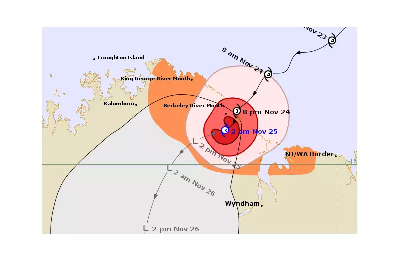
Tropical Cyclone Fina roared ashore as a powerful category three system on Monday night, tearing into the remote northern Kimberley region with destructive winds and torrential rain. The cyclone crossed the coast just before 9:30pm near the Berkeley River Mouth, where wind gusts of up to 185km/h were recorded at the time of landfall.
Emergency Warnings and Community Impact
The Department of Fire and Emergency Services has maintained an emergency cyclone warning for residents from Cambridge Gulf to areas north of Faraway Bay. Authorities have urgently advised people within this zone to take shelter immediately, confirming it is now too late to leave as the threat to lives and homes remains extreme.
Communities situated between the King George River Mouth and regions southeast of Berkeley River experienced severe battering from wind gusts reaching up to 155km/h. Meanwhile, damaging winds up to 120km/h extended along the coastline towards the Northern Territory border and pushed into inland areas east of Kalumburu.

Emergency services instructed residents to bunker down in the strongest part of their homes, keep all doors and windows securely closed, avoid waterways, and remain indoors until authorities provide the official all-clear.
System Weakens But Dangers Persist
By early Tuesday, Cyclone Fina had weakened to a category two system as it continued to push further inland. Despite this reduction in intensity, the system continued to whip the East Kimberley with squally winds and bursts of heavy rainfall throughout the night.
Wyndham received between 10mm and 25mm of rain per hour overnight, while winds at the local airport remained steady between 30km/h and 40km/h, with gusts reaching into the 50km/h range. The most severe wind conditions had shifted north and west of the town by dawn on Tuesday.
Satellite imagery captured on Tuesday morning revealed thick cloud coverage and pockets of storm activity clinging to the system's northern side as it moved inland.
Ongoing Risks and Community Alert
Emergency services have identified several continuing concerns as the weather system slowly breaks apart inland. Slick roads, reduced visibility, and the potential for sudden heavy downpours present significant hazards for residents across the region.
Along the northeast Kimberley coast, heavy to locally intense rainfall continues to pose a flash-flooding risk, though this is expected to ease later on Tuesday. Coastal communities between the King George River Mouth and the Western Australia-Northern Territory border have also been alerted that tides may rise above normal high tide marks, with large waves likely to cause minor flooding in low-lying areas.
Authorities are urging residents across the Kimberley and into the Northern Territory to remain vigilant and stay indoors until conditions properly settle. Fina's remnants are forecast to keep the region wet and windy throughout Tuesday, maintaining challenging conditions even as the cyclone continues to weaken.