A severe weather emergency is unfolding in Western Australia's north as a powerful tropical cyclone sets its sights on the coastline. The Bureau of Meteorology has issued a Watch and Act alert for the Kimberley region, with Severe Tropical Cyclone Fina intensifying into a dangerous category four system.
Immediate Threat to Lives and Homes
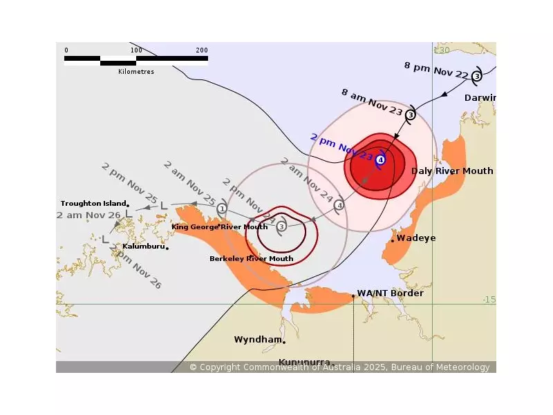
As of 3pm on Sunday, 23 November 2025, the destructive core of Cyclone Fina was located just 125 kilometres offshore and moving southwest. The Department of Fire and Emergency Services has delivered a stark warning, stating there is a possible threat to lives and homes for communities within the Cambridge Gulf and King George River areas.
Authorities are urging residents to take immediate action to get ready to shelter from the cyclone. The official warning emphasised that "no matter how many cyclones you have been through, a severe cyclone can be overwhelming", advising families to ensure they are both physically and mentally prepared if they plan to shelter at home.

Critical Preparation Steps for Residents
Kimberley locals are being directed to undertake crucial safety measures without delay. The key steps include securing all loose items around properties, ensuring emergency kits are fully stocked and accessible, and moving vehicles under cover.
Residents should also fasten cyclone shutters and board up any exposed windows. The safety of pets and animals is another priority. People in the area are strongly advised not to go out on the water and to charge their mobile phones in case of power outages.
Forecast: Destructive Winds and Flash Flooding Risk
The weather bureau warns that coastal parts of the northeast Kimberley could experience strong winds and heavy rainfall from Monday morning. The cyclone's impact could reach as far east as Kalumburu, WA.
A significant concern is the potential for heavy rainfall to lead to flash flooding along the northeast Kimberley coast on Monday. According to the Bureau of Meteorology, "Cyclone Fina is forecast to remain a severe tropical cyclone overnight on Sunday as it moves southwest through the Joseph Bonaparte Gulf."
The system is expected to start weakening quickly during Monday as it takes a track to the west-northwest near the northeast Kimberley coast. The Bureau indicates the cyclone could drop below cyclone strength by Tuesday morning, but not before delivering a severe battering to the region.