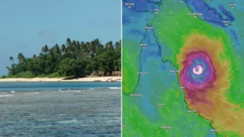
Cyclone Maila Intensifies to Category 5, Sparking Warnings and Uncertainty
Severe Tropical Cyclone Maila has rapidly intensified into a formidable category 5 system, creating heightened alertness among residents in Queensland and the Solomon Islands. The monster storm is currently lingering over the Solomon Sea, where wind gusts near its centre have reached staggering speeds of up to 280km/h or more. This intense activity is generating heavy rainfall, powerful winds, and dangerously rough seas, posing significant risks to coastal communities.
Warnings Issued for Solomon Islands and Papua New Guinea
Authorities have issued a cyclone warning for the southwest of Ranonnga Island in the Western Province of the Solomon Islands. Locals are being cautioned about potential landslides and flooding as the storm approaches. In Papua New Guinea, the national weather service has warned residents to stay away from the sea and seek higher ground until the cyclone threat passes. A current cyclone warning is in effect for Milne Bay Province, including coastal and island communities such as Woodlark, Sudet, Misima, Rossel Islands, and Bougainville.
Conflicting Forecast Models Add to Queensland's Anxious Wait
More than 1,000km away in Australia, the slow-moving giant is causing an anxious wait for both locals and forecasters. Popular climate models used by meteorologists are producing conflicting data, adding to the uncertainty. An American forecast model, the JTWC, suggests the system could cross the coast in a location similar to where Cyclone Narelle struck last month on the far north Cape York Peninsula. In contrast, a European forecast model predicts Maila will pass much closer to Cairns and at a higher strength. One weather model even shows an intense Cyclone Maila heading directly towards Cairns, raising concerns for urban areas.

Slow Movement and Predicted Weakening
What is certain is that Cyclone Maila is slowly on the move. Forecasts indicate it will turn towards the Far North Queensland coast over the weekend, with a possible coastal crossing early next week. Harry Clark, a senior meteorologist at the Bureau of Meteorology, noted that the cyclone has been very slow-moving over the past 24 hours, essentially sitting over the same spot. However, it experienced a burst of intensification yesterday and overnight, elevating it to category 5 status.
Clark explained that there are signs the system may slowly begin to weaken as it moves westward. Over the next 24 hours and few days, Maila is expected to shift southwestward and drop in intensity gradually. It is likely to be downgraded to a category 4 system by Thursday and further to a category 3 by Friday. Despite this weakening, the cyclone is still anticipated to pack a punch as it sideswipes Papua New Guinea before approaching the Queensland coastline.
High Uncertainty for Australian Landfall
In terms of where Maila will arrive in Australia, Clark emphasized that there remains a very high degree of uncertainty. Model scenarios vary widely, with potential landfall locations ranging from Lockhart River down to Cairns. At this stage, forecasters cannot be overly specific, but Far North Queensland, particularly areas north around Cairns, are considered the most likely targets. Clark described the situation as a "watch this space" scenario, with more confidence expected as the system moves closer.
Why Cyclone Maila Is Moving So Slowly
Clark attributed Maila's slow movement to weak steering influences. Tropical cyclones are typically guided by mid-level atmospheric winds, but in this case, those winds are quite weak, resulting in minimal movement. As a result, Maila has been largely stationary, not feeling significant effects from surrounding weather patterns. However, over the next few days, increased easterly winds are expected to push the cyclone southwestward, thanks to an upper ridge. Once this movement begins, forecasters will gain better insight into the direction Maila will take.

Clark expressed relative confidence that once the cyclone starts moving southwest, it will likely continue on that path. Given its distance from the coast, any slight change in the angle of this southward movement could have substantial implications for the eventual landfall location on the Queensland coast. Residents are urged to stay informed and prepared as the situation evolves.