Cyclone Narelle Unleashes Fury on Western Australia with Devastating Impact
Severe weather event cyclone Narelle has barrelled down the coast of Western Australia, leaving a trail of destruction in its wake. Heartbreaking photos reveal the cyclone's devastating impact, with some WA communities completely submerged in floodwaters as the powerful storm system continues to circulate through the region.
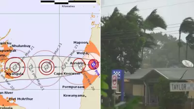
Category 4 Cyclone Makes Dangerous Approach
On Friday morning, the category four system was seen dangerously close to Exmouth where it began passing near the North West Cape. The cyclone had been upgraded to category 4 on Thursday night after rapidly gaining strength, posing significant threats to coastal communities throughout the region.
Extreme Wind Gusts and Rainfall Records
Severe impacts included wind gusts reaching up to 260km/h occurring over coastal parts between North West Cape and Onslow, with expectations that these conditions would extend south down the coast to Coral Bay and Cape Cuvier through Friday morning. On Thursday night, the highest rainfall totals were recorded with 197mm falling at Barrow Island, while gusts of up to 200km/h were recorded in Learmonth, marking the second highest wind speeds ever documented in that location.

Widespread Warnings and Evacuations
Authorities issued multiple warnings for heavy rainfall, flash flooding, and dangerous storm tides that remain active for the Pilbara, Gascoyne, and Central West regions. Before cyclone Narelle made landfall, roads were packed with residents evacuating to safer areas ahead of the worst impacts from the category 4 system.
Damage Assessment and Community Impact
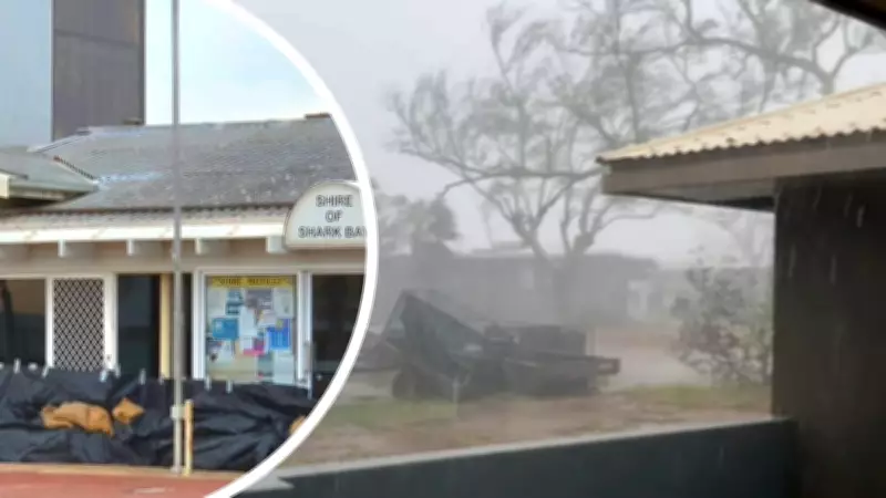
The cyclone has caused significant damage in regional towns and homes along the WA coast, with damaging winds tearing through properties and uprooting trees that have fallen through people's homes. The Shire of Shark Bay was actively preparing for the cyclone's arrival on Friday morning as the storm's intensity increased.
Storm System Weakening and Future Movement
On Saturday, the severe weather system is expected to weaken while moving south-east, impacting Central West and inland areas of Western Australia. Despite this anticipated weakening, the cyclone has already left substantial damage across multiple regions, with recovery efforts likely to continue for an extended period.
Visual Documentation of Destruction
Photographs circulating on social media platforms show:
- Floodwaters inundating communities
- Damaging winds picking up intensity across affected areas
- Properties damaged by heavy rainfall and powerful winds
- Emergency preparations underway in vulnerable regions
- Evacuation efforts before the cyclone's peak impact
The cyclone's path and intensity have created challenging conditions for emergency services and residents alike, with the full extent of damage still being assessed as the weather system continues to move through Western Australia.