Exclusive Photos Reveal Inside View of New Lambton Landslip Danger Zone
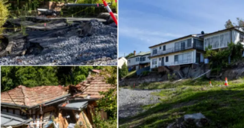
Newly released photos from inside the New Lambton landslip danger area provide a stark and unprecedented look at the extent of ground movement and structural damage in this hazardous zone. Authorities have issued urgent warnings for residents and the public to stay clear of the area, emphasizing the ongoing risks of further slippage and potential collapse. The images, captured by official sources, reveal deep cracks in the earth, displaced soil, and visible instability in the surrounding terrain, highlighting the severity of the geological event.
Ground Movement and Structural Damage Documented in Detail
The photos from inside the New Lambton landslip danger area show significant ground movement, with large sections of earth visibly shifted and fractured. This has led to concerns about the stability of nearby structures and infrastructure, as the landslip continues to pose a threat to safety. Experts are closely monitoring the situation, noting that such events can be triggered by factors like heavy rainfall, soil erosion, or underlying geological conditions. The visual evidence underscores the need for immediate caution and adherence to safety protocols to prevent accidents or injuries.
Authorities Urge Public to Avoid the Hazardous Area
In response to the landslip, local authorities have cordoned off the New Lambton danger area and are urging residents to avoid it entirely. Emergency services are on high alert, conducting regular assessments to evaluate the risk of further movement. The photos serve as a critical tool for public awareness, illustrating why access restrictions are in place. Officials stress that while the area may appear stable from a distance, the internal damage revealed in these images indicates a high level of unpredictability and danger.

Ongoing Monitoring and Safety Measures in Place
As the situation evolves, authorities are implementing ongoing monitoring and safety measures to manage the New Lambton landslip. This includes geological surveys, risk assessments, and community outreach to keep residents informed. The exclusive photos from inside the danger area are part of efforts to enhance transparency and ensure public cooperation. With weather conditions and other environmental factors potentially exacerbating the issue, vigilance remains paramount to protect lives and property in the affected region.