Monsoonal Rains Batter Queensland as Cyclone Threats Loom
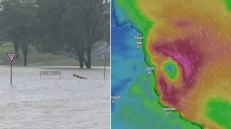
Intense monsoonal rains have unleashed a deluge across parts of Queensland, with forecasters now closely tracking two potential tropical cyclones developing in the state's northern regions. The northeast tropical coastline has been particularly hard-hit, receiving between 100mm and 300mm of rainfall from Monday night into Tuesday.
Record Rainfall and Immediate Impacts
Specific locations have recorded staggering totals, including 206mm at Cardwell Marine Parade and 209mm at Ingham Aero. Further north, Whyanbeel Valley saw 235.0mm, while Whyanbeel Creek measured 250mm overnight. Senior meteorologist Jonathan Howe emphasized that an active monsoon period is currently affecting northern Australia, bringing heavy showers and rain, especially to northeastern Queensland.
This heavy rainfall has already triggered a major flood warning for the Herbert River and a minor flood warning for the Daintree River. Howe noted that saturated catchments, combined with recent and forecasted rain, necessitate ongoing flood watches. A monsoon trough is dumping significant rainfall between Townsville and Cairns, exacerbating the situation.

Potential Cyclone Development and Forecast
Two low-pressure systems embedded in the monsoonal trough are under surveillance, with increasing chances of tropical cyclone formation. One low over the Coral Sea, currently well off the coast of Townsville and Cairns, has a 10% chance of becoming a tropical cyclone from tomorrow, rising to 25% from Wednesday. The Bureau of Meteorology is gaining confidence that this system will approach Queensland's northeast coast later this week, potentially crossing as a tropical low or cyclone.
Increased rain is expected from Thursday, more likely from Friday, extending down the Queensland coast through the weekend. Heavy rain could develop in areas such as Cairns, Townsville, Mackay, and possibly as far south as Rockhampton. Brisbane residents may see heightened showers from Sunday, depending on the system's movement, with flood risks elevated due to already saturated catchments.
Second Low and Broader Implications
A second tropical low has formed over the Gulf of Carpentaria, with a 10% to 15% chance of cyclone development from Wednesday. It is forecast to drift west and southwest toward the Northern Territory coast over the weekend, potentially bringing increased rain to the Queensland Gulf Coast and inland Northern Territory, along with possible flood risks.
Howe urged communities across Northern Queensland and Gulf areas to stay updated with the latest tropical cyclone seven-day forecasts as details become clearer. The BOM is currently tracking four possible cyclones, two of which could impact Queensland, highlighting the need for vigilance in the coming days.