Cyclone Narelle Downgraded After Devastating WA, Residents Assess Damage
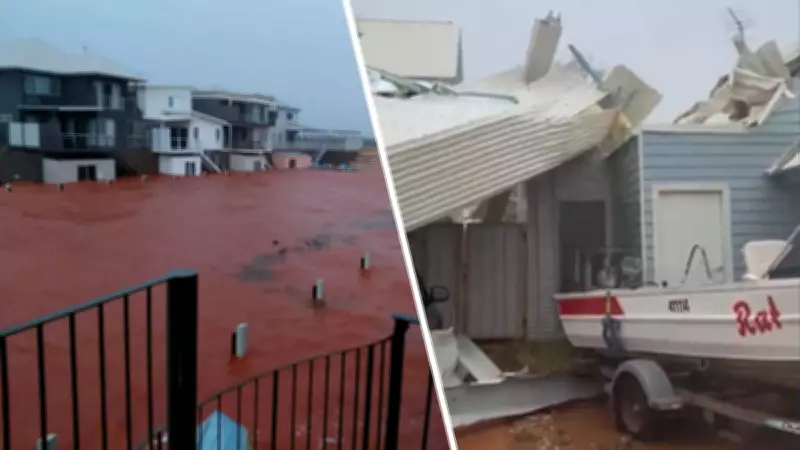
Western Australia is beginning to assess the extensive damage left in the wake of Tropical Cyclone Narelle, which has now been downgraded to a tropical low but continues to pose significant threats as it moves inland across the state. The monster storm, which initially struck as a powerful category 4 system, has left a trail of destruction along the coast, particularly impacting towns in its direct path.
Current Status and Immediate Impacts
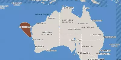
As of the latest updates, Ex-Tropical Cyclone Narelle is no longer classified as a tropical cyclone. The system has weakened into a fast-moving tropical low, currently located inland east-northeast of Geraldton and north of Morawa. It is tracking south-southeast at approximately 41 kilometers per hour, with sustained winds around 75 km/h and gusts potentially reaching up to 100 km/h.
Residents in affected areas are cautiously emerging to survey the devastation. In Exmouth, locals have described the cyclone's devastating impact, while further south in Carnarvon, communities were bracing for potential impacts as the storm approached. The skies remain overcast across many regions, with widespread rain expected to continue as the system moves inland over the Wheatbelt.

Weather Warnings and Hazardous Conditions
While the official cyclone warning and watch zones have been cancelled for areas from Gascoyne Junction to Dalwallinu, a severe weather warning remains in effect for parts of southwest Western Australia. This includes regions east of Perth and northeast of Albany, where damaging winds and heavy rainfall are still possible as the tropical low progresses.
The impacts are expected to spread across the Central West district before moving inland and south through the South West Land Division throughout the day. Authorities anticipate the system will continue weakening as it travels over land, but hazardous conditions persist.
Key Safety Information and Community Response
Emergency services are urging residents to remain vigilant and monitor official updates through Emergency WA and DFES alerts. The transition from cyclone to tropical low doesn't eliminate risks, with damaging winds and potential flooding from heavy rain still posing threats to communities in the storm's path.
- The system is moving quickly south-southeast over land
- Further weakening is expected throughout the day
- Damaging winds remain possible in warning areas
- Heavy rainfall may accompany the system as it moves inland
As recovery efforts begin in the hardest hit coastal towns, residents across Western Australia are advised to exercise caution, avoid unnecessary travel in affected areas, and heed all official warnings as the situation continues to evolve.