Cyclone Narelle Unleashes Fury on Western Australia as Coastal Communities Bear Brunt
Severe Tropical Cyclone Narelle, upgraded to a monstrous category 4 storm, has made a devastating impact on Western Australia, slamming into coastal towns with ferocious winds and torrential rains. The cyclone, described by locals as "another level" of horror, has left a trail of destruction across regions including Exmouth and Carnarvon, prompting urgent emergency responses and widespread evacuations.
Immediate Impacts and Emergency Warnings
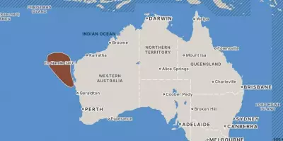
As of the latest updates, Cyclone Narelle is positioned approximately 90 kilometers southwest of Exmouth and 260 kilometers north of Carnarvon, moving south-southwest at a speed of 20 kilometers per hour. Currently classified as a category 3 severe tropical cyclone, it is expected to turn south today, passing dangerously close to the North West Cape. Forecasters predict it will weaken while moving south-southeast by Saturday, impacting Central West and inland areas of WA.
The Department of Fire and Emergency Services (DFES) has issued critical warnings, urging residents in the affected zones to monitor alerts closely. The current warning zone extends from Mardie to Jurien Bay, with impacts anticipated to spread across the central west and south west land divisions by Saturday. Wind gusts have reached up to 220 kilometers per hour between North West Cape and Coray Bay, with Exmouth experiencing gusts up to 200 km/h and Denham up to 180 km/h.

Heavy rainfall poses a significant risk of flash flooding in the Pilbara, Gascoyne, and Central West regions. Coastal hazards include very dangerous storm tides between Onslow and Denham, damaging waves, and potential coastal flooding. Elevated tides and minor flooding are also likely from Cape Preston to Onslow.
On-the-Ground Reports of Devastation
In Exmouth, residents have reported catastrophic damage, with roofs ripped from homes and widespread destruction. Rachael Wells, general manager of the Ningaloo Caravan Park, evacuated staff and visitors but is sheltering at home with her family. She described the scene as "destroyed," with trees down and roofs off across the town. "We've been through cyclone warnings before but this is next level," she said, noting that even the evacuation center's roof had lifted off, forcing people to shelter on the stage area.
Leith Holtzman, an Exmouth local, shared his harrowing experience, comparing the storm to a dinosaur trying to tear into his house. "From 4am to 6am it was horrific," he recounted, adding that he had to take shelter under a bed as the cyclone shutters were down. He emphasized that while he had experienced Cyclone Owen, Narelle was "another level" of intensity.
Residents are drawing parallels to Cyclone Vance, a category 5 storm that caused $35 million in damage in 1999. Matt Gates, a local business owner, told 6PR that the situation is "pretty scary," with ankle-deep water in backyards, roofs lost, and sheds blown apart. "It's reminding me of Vance," he said, highlighting the severity of the current storm.
Economic and Infrastructure Disruptions
The cyclone's impact extends beyond residential areas, affecting critical infrastructure and industries. Woodside Energy confirmed that its Karratha gas plant on the North West Shelf has been forced offline due to Narelle, disrupting gas production at WA's foundation LNG project. This interruption underscores the storm's widespread economic repercussions.
Additionally, the Bureau of Meteorology reported that the Learmonth weather radar, which covers the Exmouth area, has been rendered inoperable due to cyclone damage. Technicians will assess the site once it is safe, but this loss hampers real-time weather monitoring in a crucial region.
Government and Emergency Response
Prime Minister Anthony Albanese has reiterated the Federal Government's readiness to assist state and territory governments, as well as local authorities, in dealing with the aftermath of Cyclone Narelle. "My Government of course stands ready to assist state and territory governments, but also local government at this time," he stated, urging residents to follow advice from emergency agencies.

The National Emergency Management Agency (NEMA) is collaborating with the WA State Government to determine necessary federal support, with liaison officers embedded in Western Australia to provide assistance. Meanwhile, DFES has advised individuals needing help to contact the State Emergency Service (SES) on 132 500, emphasizing that posting on Facebook is not an effective way to seek assistance during the crisis.
Community and Animal Welfare Concerns
Shadow Minister for Planning and Lands Neil Thomson MLC highlighted the situation in Carnarvon, describing it as a "massive dust storm" with winds intensifying. He expressed concerns over old structures in town and predicted significant damage to regional crops, with growers resigned to substantial losses. A temporary flood levy was built on West Street to combat the predicted tidal surge, but the town's preparedness is being tested.
RSPCA WA has urged pet owners to plan proactively for their animals, as evacuation centers generally do not accept pets. Spokeswoman Louise Rowe stressed that severe weather events can be terrifying for animals, and planning ahead is crucial to ensure their safety. "Do not assume you'll be able to take your pet with you if you need to leave. You need a plan now," she advised.
Visual Evidence and Ongoing Updates
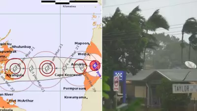
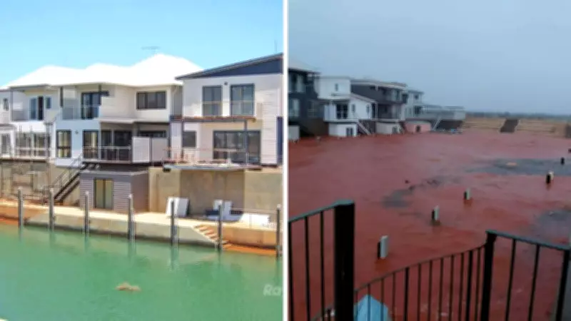
Devastating images circulating on social media show the cyclone's impact, including flooded streets in Karratha and damaged structures from the storm's powerful winds. These visuals underscore the scale of destruction as communities brace for further impacts.
As Cyclone Narelle continues its path, residents are urged to stay informed through Emergency WA and DFES alerts, know their cyclone plans, and prioritize safety. The storm's lingering effects are expected to affect northern Australia, including the Northern Territory, which is still recovering from recent floods, highlighting the broader regional challenges posed by severe weather events.