Cyclone Narelle Intensifies to Category 3, Prompting Widespread Alerts
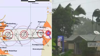
Cyclone Narelle has strengthened overnight into a Category 3 system, with widespread warnings now in place as it continues to move south parallel to the northwest coast of Western Australia. The powerful weather system is bringing destructive conditions to coastal regions, with sustained winds of 150km/h and gusts up to 200km/h near the Pilbara coastline.
Travel Disruptions and Evacuations Underway
In response to the escalating threat, Port Hedland International Airport has cancelled all Virgin and Qantas flights for Thursday. Main roads in and out of Exmouth will close from 10am Thursday, including key routes such as Burkett Road westbound at North West Coastal Highway and Minilya Exmouth Road northbound. An evacuation centre has been established at the Exmouth Shire Hall to assist residents in high-risk areas.
The cyclone, currently located about 100km offshore, is expected to strengthen further on Thursday to a severe Category 4 tropical cyclone. This will result in damaging and destructive winds impacting the Pilbara coast and islands, with Karratha, Roeburn, and Port Hedland already experiencing winds exceeding 80km/h overnight.

Expanding Warnings and Forecasted Impacts
Warnings of damaging winds have also been issued for residents along the Darling Scarp this morning, with those in the hills and foothills advised to expect winds up to 90km/h until about 10am. Communities including Armadale, Ellenbrooke, Kalamunda, GinGin, Dwellingup, and Harvey are urged to secure outdoor furniture, trampolines, and other loose items to prevent damage.
Senior Bureau of Meteorology meteorologist Angus Hines stated that wind strengths will increase throughout Thursday and Friday. Active tropical cyclone warnings are in place from Pardoo Roadhouse to Cape Cuvier, covering Port Hedland, Karratha, Onslow, Exmouth, Coral Bay, and inland to Pannawonica. Winds in these areas could exceed 200km/h later on Thursday.
Tracking and Future Projections
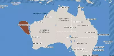
Cyclone Narelle is projected to move south-southwest along the Pilbara coast on Thursday before heading south on Friday between north of Exmouth and south of Carnarvon. It is likely to cross onto WA’s mainland as a severe Category 3 tropical cyclone, potentially impacting the Gascoyne coast between Carnarvon and Kalbarri, with areas around Shark Bay and Denham at risk around midnight on Friday.
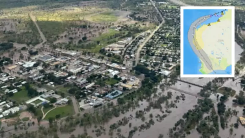
Destructive winds and dangerous storm surges are expected late on Friday and into Saturday for these regions. As the cyclone tracks past Perth, it will have reduced to a tropical low-pressure area, but significant rainfall between 50 and 100mm and strong winds are forecast for the city from Friday into the weekend, with potential for storms and flash flooding warnings extending from the North West Cape down to the Swan River in Perth.
The cyclone is most likely to depart WA from the southern coastline early on Sunday before sunrise, marking the end of this severe weather event.