I am standing on the edge of rocks, burning in the sun with the flaming hues of red and orange crayons. A wall of boulders, stacked like gigantic Lego blocks, looms across a gaping canyon vast enough to park dozens of planes in.
I look up, and the black silhouette of an Andean condor glides between me and a ceiling of immense, flattened clouds.
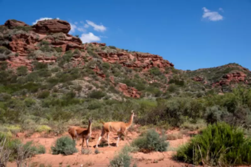
Turn around, and a guanaco — a wild llama — moves swiftly through the labyrinth of stone.

Sierra de las Quijadas National Park lies 120km north-east of San Luis, capital of the central-western Argentine San Luis province. It is the grandest of the area’s national parks, with more than 70,000ha of iron-streaked desert breaking into canyons, highland scrub, vertiginous cliffs, and wind-carved mesas.
An ancient landscape that turns even short walks into journeys across deep time.
And the best part? It remains one of Argentina’s least-visited national parks. Here is all you need to plan a visit.
All-Weather Trails
Sierra de Las Quijadas National Park is open from 8am to 5pm, with the park closing at 7.30pm. From the highway’s park turnoff, it is about 1km to the park’s information point (the only spot with wi-fi connectivity), and from here, it is another 5km to the parking area next to the trailheads.
There are three main, relatively short walking trails that can be visited year-round. The most popular — and the one that delivers the opening panorama — is the 2.3km-long Sendero de Los Miradores, looping across a mesa on the reserve’s western edge.
From here, the land falls away into Potrero de la Aguada, the park’s main basin, a vast amphitheatre of ravines and burnt-red escarpments. The Balcon Norte opens on to a sweeping view of fractured canyons dissolving into a silent, arid valley. At the Balcon Sur, also known as Miradores a Farallones, the perspective shifts toward the park’s most dramatic formation: the Farallones, a fan of 250m-high vertical rock walls sculpted by wind and water over 130 million years.
On the southern side of the parking area, the 1.7km Sendero La Flora offers a gentler, largely flat walk focused on the region’s hardy vegetation — thorny shrubs, low woodland, and desert blooms — with occasional openings on to the vastness of Potrero de la Aguada.
For something more demanding, the 5km Sendero Guanacos snakes north through terrain that feels almost extraterrestrial, where herds of guanacos are known to roam. Even if it is self-guided, this trail requires registration at the park’s information centre and takes three to four hours for the round trip.
Rangers close access if the temperature is above 29C — a reminder that, despite its beauty, this is a harsh and exposed environment best tackled in cooler months.
Guided Trails
With more time and preparation, the best of Sierra de Las Quijadas can be visited on two trails that descend deep inside the canyons of Potrero de la Aguada and require a guide — the information centre has numbers, but you need to organise one before you go.
The 3km-long Las Huellas del Pasado snakes through beautiful landscapes to some dinosaur footprints, clearly visible in the deep red sandstone rock, giving a peek at the impressive size of these long-extinct giants.
But the park’s best expedition is the 9km-long Sendero Farallones, which crosses part of Potrero de la Aguada to the feet of the striking fan of red-rock formations that you can otherwise only observe from very far away on top of the mesa.
It is totally worth it, but it is a trip requiring organisation and preparation — the tourism office on the north-western corner of San Luis’ Plaza Pringles has a list of licensed guides who can offer transportation from the city and accompany you inside this less-explored natural marvel.